
John Kingsnorth endeavours to ‘go with wind and tide’ and cover as many East Coast rivers as possible in a week in his Nova 27 sailing yacht.
Plan A was scuppered. The dreaded Deben bar is too rough in a predicted Force 6.
We would have to try again in the morning.
After struggling against adverse winds and tides during last year’s South Coast cruise we’d vowed that this year we would go with wind and tide whenever possible and see how far we could get in a week.
‘We’ being crew Jenny, a friend without a boat – but with many sea miles under her lifejacket and lots of qualifications – and me, owner of Maisie and 61 years sailing but few qualifications.
In previous years our different skills had proved to be a good combination, especially for several trips across the North Sea to The Netherlands.
Maisie is a Nova 27, which I’ve fiddled and tinkered with for nearly the last 20 years, having lots of fun along the way.
Currently, we keep her in Suffolk Yacht Harbour on the River Orwell just up from Felixstowe docks.

Maisie the Nova 27 that John Kingsnorth has owned since February 2003. Credit: John Kingsnorth
First river
So, plan B. Reading about the entrance to the River Deben is daunting stuff, you wouldn’t go within miles of it.
However, having rung the excellent harbourmaster, John White, and done our research, we were confident about navigating through the entrance in anything up to Force 5 and in the two hours before high water.
Alarm 0430, check forecast, south-westerly Force 3-5, HW 0940… let’s go.
After motoring out of the Orwell past the docks we had a good sail across the bay and whooshed at 7 knots into the Deben. It is not always so benign!
It is a beautiful river with something of interest at every twist and turn – the church snug among the trees at Ramsholt, the unexpected beach at The Rocks with early morning paddle boarders, ancient Methersgate Quay, and of course the delightful town of Woodbridge with marina boatyards and all facilities.
By 1000 the tide was turning so back down the river to pick up a mooring at Waldringfield by permission from the friendly harbourmaster.
This lovely riverside village buzzes at the weekend with the excellent Maybush pub packed and next door the thriving sailing club was full of activity for all ages and types of watercraft.
My wife was travelling by car to meet us for the evening so before she arrived we walked along the shore and watched the dinghies racing, the most spectacular being the Lasers.
How do they handle those spinnakers so adeptly?

John sailed Maisie up the River Deben as far as Woodbridge
Second river
We didn’t fancy going out over the bar against the flood or on a falling tide so the aim was to be at Felixstowe Ferry on or just before HW at 1100.
We dropped the mooring at 0800 on one of those glorious English summer mornings – a pale sun, ripples gently slapping the hull, wooded riverbanks, and a couple of brave women swimming by the sailing club.
Sipping our coffee we made slow, silent progress against the tide in awe of the surroundings.
The engine went on at Ramsholt to catch the tide and we had another easy escape over the bar and out towards Felixstowe dodging the lobster pots.
The Deben at its very best… phew.

View across Waldringfield harbour on the River Deben. Credit: John Kingsnorth
Towing the dinghy, which we needed at Waldringfield, was a pain out at sea so we decided to ditch it back at Suffolk Yacht Harbour, take on diesel, then shower before catching the evening flood to take us down to The Blackwater.
By 1700 we were romping past The Naze at 6 knots on a starboard tack with a steady westerly Force 4.
Digression here, if I may. Maisie has a 20-plus years old Furuno GPS which is still in excellent working order. The boat’s log impeller under the hull gets constantly clogged up with East Anglian weed so I rely on the GPS for speed over ground (SOG).
I also now have a backup with an Aquamaps app (thanks to Rupert Holmes for the tip).
This proved to be invaluable in fog off Dover last year along with calm, professional help on the VHF from Dover Control.
I see all these wonderful chartplotters and suchlike advertised in the mags often for four figures which is beyond my budget.
Thus far I have dealt with most things over 20 years on Maisie sailing between Falmouth and Lowestoft with paper charts, handheld and fixed VHF, GPS, Almanac and recently the app on my mobile. Is my parsimoniousness putting safety at risk? I think not. Digression over!
We were earlier than anticipated in the channel into The Blackwater so had an uncomfortable wind-over-tide beat with engine help to clear Bradwell, but a lovely late evening sail down the estuary before picking up a mooring at 2130 off Marconi Sailing Club.
Finally, a glass of wine watching the sunset over Osea Island and off to bed on our second river.

Sunset at Osea Island. Credit: John Kingsnorth
Basking seals
We convened over breakfast and decided on Burnham-on-Crouch as the day’s destination via West Mersea.
Maisie does not go well on mainsail alone but if you want a quiet drift with the tide the jib does it nicely so at 0800 we set off upriver past Osea. What a fascinating place with an interesting history.
Maldon is attractive but difficult to land and get supplies so we turned and made for West Mersea with some apprehension as the approach channels looked alarmingly narrow on a chart.
Just before HW, we were following withies with 2m under the keel hoping there’d still be at least 1m in a couple of hours.
West Mersea is brilliant and I can’t wait to return. Mooring is easy; quick, free, helpful water taxi; lots of eateries; delightful walk to a good supermarket; 1.5m under keel leaving two hours after HW.
It was inspiring to see so many people covering all generations having a great time in a harbour where everything seemed geared toward making life easy and fun.
Quite a contrast to some of our experiences on the South Coast the previous year.
From Swin Spitway to Burnham is about 14 miles so you really do want some favourable tide somewhere.
We crossed Wallet Spitway near LW with 1.5m under the keel and used Aquamaps to make doubly sure we were in Swallowtail.
A passing RNLI rigid inflatable boat towing a motorboat added to our confidence. It was good to see lots of seals basking on the sandbanks.

Seals on Hamford water nature reserve, Essex. Credit: Mark Baigent Environment/ Alamy
With wind and tide giving us 6 knots we were in the marina by 2000. Burnham Yacht Harbour is in a splendid position, has friendly staff and good facilities… but the finger pontoons are really wobbly making any landing or departure nerve-wracking.
Well done crew for staying upright.
Another digression, if I may. What does an owner/skipper expect of crew, especially if they are the only one?
Jenny tends to take care of catering and somehow produces nutritious and filling lunches no matter the sea conditions.
She also produces delicious coffee at regular intervals when off watch.
She has circumnavigated Britain and experienced an Atlantic gale off northern Spain so I have much to learn from her. She learns from me too after my 61 years of ‘the feel’ of sailing many craft.
All decisions on destination and course adjustments are discussed first, we share helm every half hour, and the only concession we make is that I do most of the foredeck work, especially when things get lively. It’s a nautical partnership which seems to work.
Change of scenery

Maisie’s spinnaker operates much more easily thanks to the new snuffer John’s wife made. Credit: John Kingsnorth
To explore the Roach from the Crouch you will be against the tide at some point and indeed it was as we motored into the teeth of an aggressive spring tide at 1100.
All change as we entered the labyrinth of channels that make The Roach.
On one reach we even got the spinnaker up thanks to the new snuffer that my wife made over the winter.
Having got used to the tree-lined rivers of the Deben, Orwell and Stour the Roach seemed bleak but you certainly feel away from it all in the upper reaches.
There is an enticing remoteness about The Roach despite the proximity of high-rise residential Southend and the regular boom of artillery on Foulness.
The tide was running strongly as we turned back down river and crew managed 7.4 knots… SOG of course!
Wind was good for heading further up the Crouch which was fun against the tide. We turned just before Fambridge Yacht Haven tacking downriver with a lot of help from the tide and were back on our wobbly pontoon at 1700.
If you’ve not been to Burnham you are missing a treat. There is a delightful mile-long walk along the shore from marina to town with views of evening dinghy races and smart houseboats.
The real draw is the range of eateries and the curry house we chose did not disappoint – sizzling dishes brought to the table.
We had a veritable feast before staggering back towards the sunset and cosy bunks. Thank you, Burnham and our third and fourth rivers.

The rivers Blackwater and Roach provided contrasting sailing and scenery
Majestic Stour
After much discussion we both agreed an early start would give us significant tide to assist exiting the Crouch even if it didn’t help later.
Here is the passage plan, which we just about stuck to:
- 0500 off, hope for 5 knots
- 0545 Inner Crouch SWM buoy
- 0630 Buxey No2 North Cardinal buoy against flood tide
- 0800 Swin Spitway
- 1100 Clacton Pier
- 1330 Walton Pier HW, expect help north with ebb
- 1430 Pye End SWM buoy
- 1600 Drop anchor, Hamford Water, Walton Backwaters.
Later, over a glass of wine to a cacophony of seabirds on the mudflats nearby, we realised we could have used the flood tide to go up the Colne to Brightlingsea for lunch and then used the ebb to go north up the Wallet, probably arriving in the Backwaters only a couple of hours later than we did.
We should have learnt from Bob Roberts and the other barge skippers of yesteryear. Ah well, next time.
At least we were able to enjoy a long, sunny evening in the Backwaters.
After calling my grandson with some whispered happy birthday greetings before he went to school – being mindful of how sound carries on an anchorage (hint to noisy boat gatherings), we turned our attention to a day on the Stour.
Again, the wind and tide were in our favour, so weigh anchor at 0900 (filthy job!) and gently down to Pye End at 2 knots against the tide.
Now with the flood, we made rapid progress past Harwich and into the Stour passing a resplendent Sir David Attenborough (the ship!) up from the Antarctic.
Five miles downwind ahead. Spinnaker? Snuffer?
This time it was a doddle though the photo I took for my wife didn’t do the ease of the procedure justice. (£20 for the material, £2 for a bucket, £2 for sewing machine needles, and bits and bobs lying about to haul it up and down – brilliant. My kind of gizmo.)
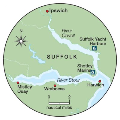
The Stour is majestic. Once past the Harwich quays it opens out into wide tree-lined shores with Wrabness and its quirky beach huts on the south side facing grand architecture and woodland walks on the north side.
I’m loath to spread the word about this magical place as it is fine just as it is. We turned at HW at Mistley Quay and enjoyed big tacks across the estuary over banks only navigable near HW.
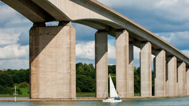
As the tide gathered pace we raced past Shotley at 7.2 knots and then of course crept up the Orwell but still sailing.
Those in a hurry swept by burning diesel but knowing our home berth was waiting we happily took the slow option mooring at 1700.
I’m not against sailing boats using their engines but I do try and sail if at all possible so today was a good day in that regard – 8 hours, 24 miles, 25 minutes of engine.
So often the Stour gives an excellent day’s sailing and river number five did so again.
Sixth river
Strangers see your boat sailing, but unless they know you they can’t send a picture. I wanted more photos of Maisie under sail and conditions were perfect.
Jenny would sail up and down a stretch of the Orwell and I would take pics from the dinghy.
A passing couple in a yacht thought we’d had a tiff and I’d abandoned ship but otherwise, all went well.
Not only do I have pictures but I could see that Maisie’s bottom was not as slimy as I feared. There seems to be a lot of weed about this year.
After returning the dinghy to Suffolk Yacht Harbour we set off up the Orwell on a rising tide and with a south-west Force 4 reached the bridge after an hour or so and turned for home.
Gusts kept us on our toes and even against the tide we made good time and were berthing at 1530. A spanking sail to finish the week.
The Orwell is a more challenging river to sail than the Stour as it is much busier, narrower, and has more twists and turns but there is plenty to see whether it be Pin Mill or luxurious yachts on trials down river from the boatyards in Ipswich.
Most of my sailing life has been in Cornwall and I foolishly developed a rather snooty attitude towards the East Coast. I was mistaken.
There are far worse places to have a boat and few better.
Of course, it’s nice to have a destination in mind on a summer cruise and we have enjoyed a number of trips to The Netherlands but there is always that nag in your mind about whether conditions will be favourable to get you home on time.
No such concerns this year, very little flogging against natural forces of wind and tide, old haunts revisited and new ones explored and enjoyed.
One week, excellent crew, 202 miles, six rivers and a backwater. Well done, Maisie, old girl.
East Coast rivers cruising advice

Yachts approaching the River Deben, Suffolk, should beware the shifting shingle banks and bar. Credit: Sunpix Marine/Alamy
Charts:
- Imray – my favourite as their colours are intuitive: green for land, yellow for tidal sand and the darker the blue the deeper the water. n C1 Thames Estuary, 1:120,000 (for
an overview) - 2000 series charts portfolio: Suffolk and Essex coasts (this comes in an A2 portfolio with 10 individual charts at 1:35,000 for each river)
- Digital charts Apps – My choice is Aqua Map – £19.99 per year for all the UK, and even a dinosaur like me can use it! Crew’s choice is Navionics (more expensive but more versatile if you can handle the tech). I have become a total convert to the wonders of what your mobile can do in a maritime context. It is particularly useful at night, in a narrow channel and for anchoring in little nooks and gauging depths.
Books
- Reeds Eastern Almanac: Essential as it has chartlets of marinas and anchorages, telephone numbers and VHF of harbourmasters and boatyards, facilities available and costs, tide tables, tidal streams and tidal curves, most buoys with their positions and light characteristics. There is plenty more – it really is a splendid annual publication.
- East Coast Rivers Cruising Companion by Janet Harber: Good pilotage advice and lots of pictures.
- OS Landranger maps 168, 169 cover the areas in this article if you fancy some walking.
Onboard equipment
Of all the standard equipment on a modern yacht, East Coast sailing needs a reliable depth gauge and an anchor you can trust. And don’t forget a brush to clean the mud off!
About the author

John Kingsnorth
John Kingsnorth is a retired teacher, based in Suffolk. He began dinghy sailing aged eight on Lake Naivasha, Kenya. Since then he has sailed various craft in Canada, New Zealand, Croatia, Thailand, The Netherlands, Gibraltar, and Britain from the Severn Estuary to the Wash. Scotland is on his wish list.